Thursday, December 6, 2012

New Zealand in the future


When it comes to the geography of an area we know that over time it changes. Areas go from an aquatic area with many marine animals and fish to an arid desert, or vice versa. There are many factors that can change the geography of an area over the course of time. So with that in mind we can speculate into the future of New Zealand, we can look at various possibilities on new formations and erosions processes that will change the land many years from now.

It is no secret that New Zealand over the past millions and billions of years has formed and shaped. Every piece of land that is visible now at one point either was not there or drifted from its original spot, New Zealand is no different. It being an island means it either broke off of a bigger land mass and drifted away due to plate tectonics or that it was created by under -water volcanoes and hot-spot migration. It is generally believed that New Zealand broke off a larger section of land and drifted (www.teara.govt.nz). 

That being said in the future New Zealand will continue to drift, as will all land masses, that is just how plate tectonics work. It will most likely collide with another continent. This will create an opportunity to create new mountains when the two land masses collide, one part of land will fold under the other part. The creation of new geographical formations does not stop there. Many of the rivers on the South Island are braided rivers, and are very thin, in many years’ time it is possible that these small rivers could dry up, possibly creating a more dry and arid landscape than what we see now. Meandering rivers could eventually erode away existing formations and create a large lake, or they could dry up and create a desert. There are many possibilities the future holds.

An interesting possibility to consider is what if an earthquake or another natural disaster greatly alters the landscape? Earthquakes have great force and can be devastating to the land; a seismic quake could easily tear one or both of the islands apart. New Zealand is part of the Pacific Ring of fire and more than 20,000 earthquakes occur each year(Wikipedia.org), although most of them are fairly tiny. Over time this can add up, also it is possible that a giant one would happen and greatly impact the islands. How the islands are impacted could vary, it would no doubt hurt many people, that is, if we are still around hundreds of thousands or millions of years from now.

We have heard a lot about global climate change and the melting of polar ice. If that is true and all (or most) of Earth’s ice melts then a lot of islands (including New Zealand) will most likely be under water. Most of the land we see today could be beneath the ocean if ice continues to melt at the rate it is currently melting at.


There is no definite ways of knowing for sure just how New Zealand will be impacted in the future. All we can do is make educated guesses and speculate based on the past and the current information we have available to us. The only thing that is for certain is that things will change and the world will look very different in a million years, if only we could be around to see how different.

Tuesday, November 13, 2012

Soil of New Zealand

The soil in New Zealand is different and varied. There are around 1,700 to 1,800 different soil series. Each series has up to six individual soil types. This may seem like a lot for one place to have but when you take into account how many there are in the world it makes sense. The soil of a tropical area will not be the same as a cooler or drier area obviously.

The North Island is where one will find most of the red-brown and yellow-brown volcanic loams. Of course the soil is generally mixed and not always easy to classify. Loamy soil is quite useful for agriculture because of the organic matter and other particles within the soil itself.

On the South island yellow-gray and yellow-brown soils are predominate. This soil is also generally acceptable for farming and thus farming can take place on both the islands because of the rich soils found on each.

There are two different systems in New Zealand for classifying soil. One system is more scientific in it's terms and are based on the soils development, the other system is more image based and goes off how the soil looks instead of it's developmental process. The most common soils found in New Zealand are brown, and semi-arid. Rainfall has a major effect on the soil and can shift and move the soil into new areas at any given time. Areas with different levels of precipitation are going to have different soil types, dampness can really effect the types of soil.


Thursday, October 11, 2012

Climate of New Zealand

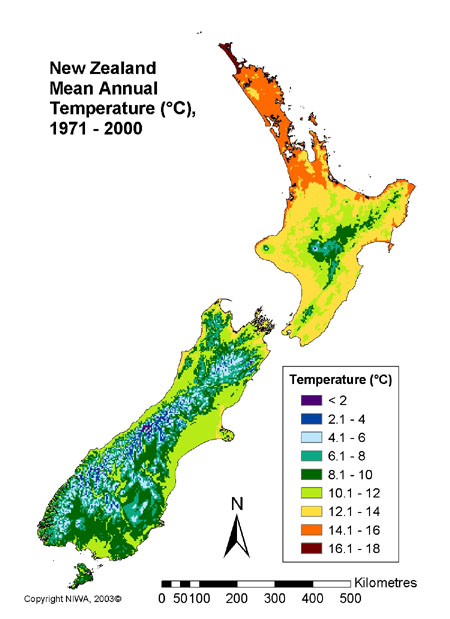
The climate of New Zealand is as varied and as interesting as the unique and beautiful scenery found around the island. The complex climate goes from warm tropical regions in the far north, to cool temperatures in the far south in the alpine mountain areas. Mountains running the length of New Zealand provide relief from the westerly winds. This divides the the country into different climate regions, the south western coast is the moistest part of the entire country while an area just east of the mountains just 100km away is the driest.
teara.govt.nz


 Most of New Zealand experiences between 600 and 1600mm of rainfall throughout the year. Although there is a dry period typically during the summers. In the north and central of the country most of the rain falls in the winter time, however to the south it is a different story and winter is the time of the year that experiences the least amount of rainfall. The snow that New Zealand has mainly falls in the mountainous areas, the east and south if the South island may experience some snow during winter though. The North island is more tropical and does not really have snow.

Annual temperatures usually range from 10 degrees Celsius in the south to 16 degrees Celsius in the north. The warmest months in New Zealand is usually January or February while the coldest month is July. To an American that seems a bit backwards, but when you consider New Zealand is south of the equator it actually makes sense.


teara.govt.nz

wwp.greenwichmeantime.com


Thursday, September 20, 2012

Landscape and formation

New Zealand is known around the world for it's beauty. However, what some people might not realize is that it has high mountain ranges and also frequent earthquakes. The reason for this is because of New Zealand's position on the border of the Australian and Pacific tectonic plates. There are two islands that make up New Zealand, the North and South islands. These plates colliding caused the Pacific plate to subduct under the Australian plate, the Northern Island is in these plates. In the South the situation is the other way around. In New Zealand the subduction zones are made apparent by the trenches to the south and the north by the Alpine Fault that connects the two. These plate boundaries are the reason for the size and shape of New Zealand.

                                                            image courtesy of records.viu.ca

Being a resident of New Zealand means the inhabitants will sometimes have to deal with earthquakes due the the position on the islands on the plates. They can range from slight rumbles to higher up on the Richter scale. 

Wednesday, August 29, 2012

Introduction-New Zealand

Dear blog,

My name is M. Tyler Mendenhall, the "M" is silent. I am a sophomore at CU Denver, I'm 19 and I am majoring in Communications. This fall I will be taking a field trip of the mind to New Zealand. Now dear reader you may find yourself asking why New Zealand Tyler? Well I love Lord of the Rings. All three movies were shot in New Zealand and it looks freaking amazing, so I figured I would study up on this magical place and this is my chance to do it.